Energy Musings - June 10, 2023
Steel in the water." The first Vineyard Wind foundations were pounded into the ocean floor last week. This is happening without a solution to radar interference from WTGs and DoD concerns.
Our Next Open Border Courtesy Of Offshore Wind?
“The border is not open,” declares Homeland Security Secretary Alejandro Mayorkas as the media shows video of thousands of illegal migrants crossing our southern border with Mexico. Do not worry, nothing bad is going to happen. But many unsavory people, including some on the terrorist watch list, have crossed, let alone the drugs and sex trafficking.
Is it possible the Biden administration will open another border? I am not talking about our Canadian border. I am focused on the East Coast where offshore wind turbines can interfere with our long-range radar (LRR) and short-term radar (SRR) which are key to our national defense. Only recently has the Department of Defense expressed serious concern about offshore wind impacting its ability to execute its mission, but they have been worried for years. Radar interference from offshore wind turbine generators (WTG) is a serious issue with no apparent solution.
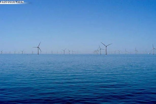
In 2003, Cape Wind was supposed to be the first U.S. offshore wind farm with 130 WTGs producing 468 MW of electricity.
We first delved into the radar interference issue when writing about the Cape Wind offshore wind farm in the early 2000s and its struggles for approval. The 468 megawatts (MW) wind farm would have been the first U.S. offshore wind farm. The power was to come from 130 3.6 MW WTGs installed in a 25-square mile section of Horseshoe Shoal in the federal waters of Nantucket Sound bounded by Cape Cod, Nantucket Island, and Martha’s Vineyard. Fierce political opposition from Massachusetts Senator Edward Kennedy (D), former Massachusetts governor Mitt Romney (R), conservative industrialist William Koch, and philanthropist Rachel “Bunny” Mellon helped kill the project.
One issue that emerged during Cape Wind’s approval process was concern about radar interference by WTGs expressed by the Coast Guard and U.S. Navy. They were concerned about the impact on their operations and training. During the approval process, two radar interference studies were “submitted that attempt to assess the impact of the proposed wind turbines on typical marine radars used in the Nantucket Sound area.” Because “(n)either of the two documents fully evaluated the impact of the actual wind turbines proposed for the Cape Wind project,” the Coast Guard commissioned a third study, the results of which were reported in January 2009. A key conclusion of the study conducted by Technology Service Corporation was:
“Although it cannot be shown in a still image, the sidelobes and false targets constantly change over several frames or even from frame to frame. As the radar moves, the orientation of individual turbines changes with respect to the radar. This changes the reflectivity, which changes the extent of the beamwidth/sidelobe spreading and also changes the reflectivity to secondary (false) reflections.”
What it means is that a marine vessel might receive significant false radar images confounding the job of navigating by or in the wind farm. As a result of what the study found, the report concluded:
“Targets outside the wind farm are easily detected and easily noticed. Targets within the windfarm, however, compete with numerous false targets caused by the turbines. These false targets are caused by a combination of sidelobes and secondary reflections. Of the two, the more distracting seem to be the secondary reflections.”
While the Coast Guard assessed the impact of the WTGs on vessel navigation radar operating in Nantucket Sound as a “moderate risk,” the concerns about the problem and finding mitigating solutions continued. Previously, radar interference was encountered with onshore WTGs, but these structures were smaller than the offshore WTGs being proposed, and the areas where radar was blocked could be covered by overlaying radar from nearby radars not interfered.
The Radar Problem
What is the issue for mariners including the Coast Guard and U.S. Navy? TSC modeled the radar interference and was able to identify false signals for multiple types of vessels that would show on a vessel’s radar screen. Determining the real signal from false ones will be a challenge for mariners, especially when they are inside the wind farm in transit or working such as fishing vessels.
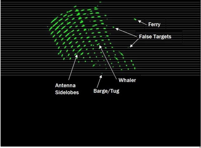
An example of the false signals is shown in the following exhibit. This was one of many examples in the study and replicated in later studies. The TSC study determined that the orientation of the WTGs can impact the number and duration of false signals and how marine radars are impacted, depending on where the target vessel and the radar are located. Not only do the wind turbine tower and the blades create radar reflections, but the number of signals is increased by the multiple reflective surfaces of the WTG’s nacelle – the location of the generator, gearbox, drive train, and brake assembly. Redesigning WTGs and constructing them from different materials are mitigations suggested by researchers, but the ideas would create other problems.
A modeled screen showing false signals for vessels not present creating confusion for mariners navigating in or near offshore wind farms.
In 2013, the Department of Energy commissioned a study – Assessment of Offshore Wind Farm Effects on Sea Surface, Subsurface and Airborne Electronic Systems – by the University of Texas to further assess the issues. The UT study authors wrote:
“Investigations on the effect of offshore wind farms on marine navigation have been conducted as early as 2004… measurements were collected on marine radar, communications and positioning systems…It was found that the effect of wind farms on radar systems is prominent, while those on communications and positioning systems are minor….It was found that wind farm induced clutter was clearly visible on radar screens….In the US, studies on offshore wind farm effect on marine navigation have focused on the Cape Wind project in Nantucket Sound, MA [EM-1.US1, EM-1.US2, EM-1.US3, EM-1.US4] and the US Coast Guard [EM-1.US1]. In [EM-1.US1], it was shown that wind farm induced clutter on radar screens can be modeled through radar simulation, and the simulations resembled the measurements reported in the Kentish Flats study. Subsequently, the US Coast Guard issued an assessment of ‘moderate risk’ in [EM-1.US2] for the presence of offshore wind farms on marine navigation for Cape Wind.”
The Kentish Flats project, located near approaches to the Port of London, was the subject of a 2006 study on radar interference by the British Wind Energy Association. At that time, WTGs were smaller and less powerful, and vessels used earlier generations of marine radar. The 2007 report described radar reflections, mirror images, and other phenomena seen by operators. Kentish Flats contained only 30 WTGs. Now, planned WTGs are two-to-three times larger as wind farms now will have 60 turbines to100s of turbines.
A later study - Ground-Based Coastal Air Surveillance Wind Turbine–Radar Interference Vulnerability Study Public Summary – examined the radar interference issue and made the following points.
“The effects of land-based wind turbines on radar systems are well understood. Wind turbines within radar line-of-sight can increase clutter that may inhibit target detection, increase the generation of false targets, interfere with target tracking, and hinder weather forecasting. However, the effects of offshore wind turbines on U.S. coastal radar systems are not well understood due to the lack of operational wind facilities for empirical study. Offshore wind turbines may pose unique impacts to coastal radar systems given the differences in propagation of radar signals over the ocean versus land, as well as the larger size of offshore wind turbines compared to land-based wind turbines.”
The Military’s Concerns
So, how do you mitigate the problem of LRR and SRR interference from offshore WTGs? As is done with onshore radar, “one mitigation approach would be to fuse output from a nearby unimpacted LRR or SRR.” In other words, backfill the vacant area with radar signals from nearby unimpacted radar. But as the study pointed out, “there are some lease and planning areas, particularly those along the coasts of Hawaii, as well as Massachusetts and Rhode Island, where unimpacted overlapping coverage does not exist and different mitigations would be needed. It is also important to note this fusion mitigation approach cannot restore low altitude coverage from 500-1000 feet AGL [above ground level].”
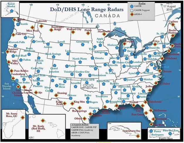
When we consider the Department of Defense (DoD) and Homeland Security map of our LRR locations, it becomes clear how susceptible our coastlines are to becoming unprotected if radar is disrupted and we cannot backfill the void. The ARSR-4 (red diamonds) radar is the most susceptible to this radar interference/blackout.
Coastal radar signals blocked by offshore wind farms are not easily replaced with backfill from nearby radar not impacted by the wind farms.
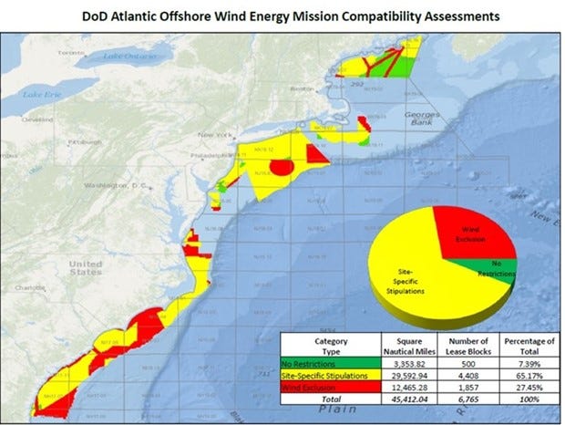
This radar interference issue led the DoD to protest the location of East Coast wind farms or request site-specific restrictions. These objections ensure that the DoD is capable of meeting mission objectives. The following map shows the specific areas the DoD has identified along the East Coast where it wants no offshore wind (red), areas where it requests site-specific restrictions (yellow), and areas with no restrictions (green). According to the data, nearly 27.5% of the area is to be completely restricted, over 65% should have site-specific restrictions, and barely 7.5% would have no restrictions.
The military has identified East Coast areas where they do not want any offshore wind farms along with areas where they need to be restricted if we can protect our borders.
As noted by numerous studies, the U.S. lacks offshore wind farms to be studied. Only the Block Island Wind Farm (BIWF) and the Coastal Virginia Offshore Wind pilot project are operating. Many radar interference studies looked to study the impact of the five WTGs at BIWF. The MIT Lincoln Laboratory study concluded that: “Compared to the baseline false alarm rate in the area around Block Island, the wind turbines increase the false alarm rate by approximately two orders of magnitude.” That would seem to be a significant issue given the few WTGs and areas covered. Other studies state that BIWF is too small to provide any conclusive evidence transferrable to how radar may be impacted by the larger wind farms being built.
Last year, the Engineering body within the National Academies of Sciences, Engineering, and Medicine produced a consensus study - Wind Turbine Generator Impacts to Marine Vessel Radar – commissioned in 2021 by the Bureau of Ocean Energy Management (BOEM). The study’s conclusions did little to advance knowledge about the radar interference issue and offered no solutions. The study had two conclusions.
“Conclusion 1: Wind turbines in the maritime environment affect marine vessel radar in a situation-dependent manner, with the most common impact being a substantial increase in strong, reflected energy cluttering the operator’s display, leading to complications in navigation decision-making.”
“Conclusion 2: Opportunities exist to ameliorate wind turbine generator–induced interference on marine vessel radars using both active and passive means, such as improved radar signal processing and display logic or signature-enhancing reflectors on small vessels to minimize lost contacts.”
These conclusions are consistent with those of all the studies since at least 2003. What we know is that radar interference by WTGs is a problem and there is no known solution. Some steps can be taken to mitigate some of the impacts, but that does not guarantee that these mitigating steps will prevent accidents, structural damage, and possibly the loss of life.
The most recent development comes from an update by the Wind Turbine-Radar Interference Mitigation Working Group (WTRIMWG), which is composed of representatives from the DoD, the Department of Energy, the Federal Aviation Administration, the National Oceanic and Atmospheric Administration, and BOEM. It plans “by 2025, to fully address wind turbine radar interference as an impact to critical radar missions, ensure the long-term resilience of radar operations in the presence of wind turbines, and remove radar interference as an impediment to future wind energy development.” How many hundreds of WTGs will be installed and working by 2025? Moreover, what solutions will be proposed, if any are developed, and how long might those solutions take to reach the marketplace?
One wonders whether wind farms will experience what Speaker of the House Nancy Pelosi (D-CA) declared about Obamacare in 2020: "We have to pass the bill so that you can find out what is in it." Will we have to build offshore wind farms to find out how dangerous they may be? Open borders; aircraft crashes; vessels hitting WTGs; foreign submarines hiding in wind farms, and the Coast Guard unable to conduct search and rescue operations - is that our future? Who in government will own up to such an outcome?


Easy solution is the military destroys the wind farms as necessary. You say oh no!! Well yes, yes!
The studies point out the change in values with blades at different positions - what if they are in a fixed position? And if that’s necessary to remediate the problem, why have them at all?
The current administration is a total clown show.